


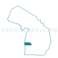
Voting District 1215632000013, Muskegon County, Michigan
About
Outline

Summary
| Unique Area Identifier | 598474 |
| Name | Voting District 1215632000013 |
| County | Muskegon County |
| State | Michigan |
| Area (square miles) | 4.76 |
| Land Area (square miles) | 1.24 |
| Water Area (square miles) | 3.52 |
| % of Land Area | 26.02 |
| % of Water Area | 73.98 |
| Latitude of the Internal Point | 43.22396600 |
| Longtitude of the Internal Point | -86.32272810 |
Maps


Graphs
Select a template below for downloading or customizing gragh for Voting District 1215632000013, Muskegon County, Michigan


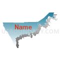


Neighbors
Neighoring Voting District (by Name) Neighboring Voting District on the Map
- Voting District 1214516000004, Muskegon County, MI
- Voting District 1215632000004, Muskegon County, MI
- Voting District 1215632000006, Muskegon County, MI
- Voting District 1215632000010, Muskegon County, MI
- Voting District 1215632000011, Muskegon County, MI
- Voting District 1215632000012, Muskegon County, MI
- Voting District 1215864000001, Muskegon County, MI
- Voting District 1215914000007, Muskegon County, MI
- Voting Districts not defined, Muskegon County, MI
Top 10 Neighboring County Subdivision (by Population) Neighboring County Subdivision on the Map
- Muskegon city, Muskegon County, MI (38,401)
- Norton Shores city, Muskegon County, MI (23,994)
- Laketon township, Muskegon County, MI (7,563)
- North Muskegon city, Muskegon County, MI (3,786)
- County subdivisions not defined, Muskegon County, MI (0)
Top 10 Neighboring Place (by Population) Neighboring Place on the Map
Top 10 Neighboring Unified School District (by Population) Neighboring Unified School District on the Map
- Muskegon City School District, MI (36,988)
- Mona Shores Public School District, MI (23,104)
- Reeths-Puffer Schools, MI (21,505)
- North Muskegon Public Schools, MI (3,784)
- School District Not Defined (Water), MI (243)
Top 10 Neighboring State Legislative District Lower Chamber (by Population) Neighboring State Legislative District Lower Chamber on the Map
Top 10 Neighboring State Legislative District Upper Chamber (by Population) Neighboring State Legislative District Upper Chamber on the Map
Top 10 Neighboring 111th Congressional District (by Population) Neighboring 111th Congressional District on the Map
Top 10 Neighboring Census Tract (by Population) Neighboring Census Tract on the Map
- Census Tract 23, Muskegon County, MI (5,699)
- Census Tract 18, Muskegon County, MI (4,775)
- Census Tract 42, Muskegon County, MI (3,963)
- Census Tract 15, Muskegon County, MI (3,770)
- Census Tract 9, Muskegon County, MI (3,529)
- Census Tract 8, Muskegon County, MI (3,152)
- Census Tract 16, Muskegon County, MI (2,672)
- Census Tract 10, Muskegon County, MI (1,230)